
The Great Smoky Mountains contain more than 2,900 miles of streams and an estimated 600 named waterfalls, distributed across four distinct drainage corridors that this four-day tour covers in sequence. Each day follows one corridor from trailhead to overlook, reducing backtracking and making it possible to see the full range of falls types—wide curtain drops, narrow plunges, multi-tiered cascades—without covering the same ground twice. Wet shoes are the baseline; the route is built around that assumption.
Day 1: Roaring Fork Motor Nature Trail
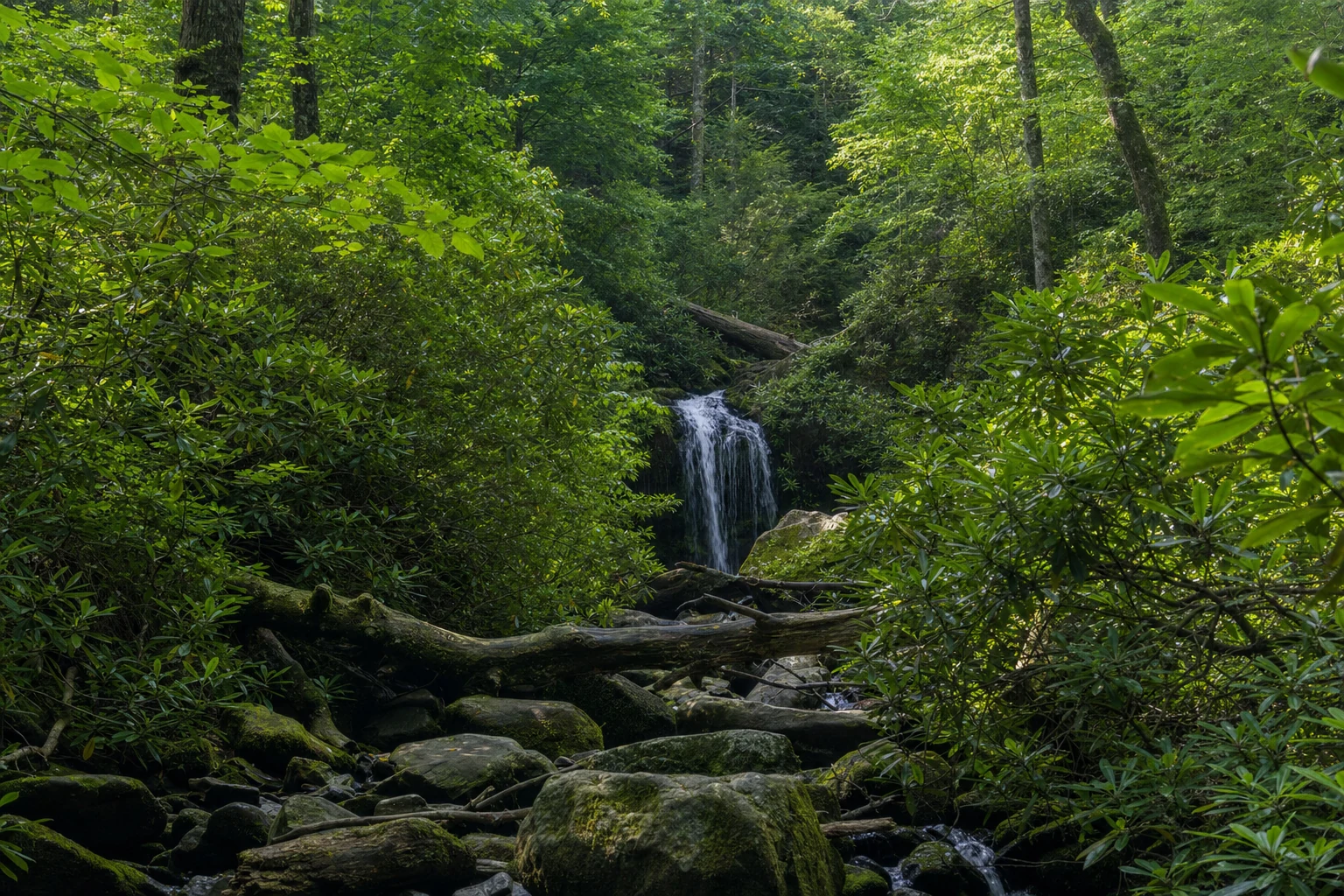
Grotto Falls (Trillium Gap Trail, 2.6 miles round trip, moderate): Start at the Roaring Fork parking area no later than 7:30 AM to beat the first wave of visitors. The shaded hemlock forest keeps temperatures down even in summer, and the falls—a 25-foot drop over a sandstone overhang—are notable in the national park because the trail passes directly behind the curtain of water. Budget 1.5 to 2 hours.
Rainbow Falls (2.7 miles round trip, 80-foot drop, moderate): Continue to the Cherokee Orchard Road trailhead. The climb gains roughly 1,500 feet, and the falls reward the effort: water narrows to a single column before spreading on impact. In strong midday sun, the mist creates visible rainbows. Allow 2.5 hours.
Laurel Falls (1.3 miles round trip, 80-foot drop, easy): Drive out to Little River Road for the afternoon. Laurel Falls is the park's most-visited paved trail, and the two-tiered drop over a natural rock shelf is worth seeing regardless of how busy the lot gets. Leave by 1 PM to secure parking. All three trailheads require a Park-It-Forward parking tag, available at self-service kiosks at the trailheads.
Optional addition: Ramsey Cascades (8 miles round trip, 100-foot drop) in the Greenbrier area east of Gatlinburg is the tallest waterfall in the national park and a full-day alternative if you prefer one sustained hike over three shorter ones.
Dinner: Calhoun's Gatlinburg.
Day 2: Tremont Road and the Townsend Corridor
Abrams Falls (Abrams Falls Trail, 5 miles round trip, moderate): Drive Cades Cove Loop Road to the trailhead near the Abrams Creek bridge. The trail descends to a falls that produces far more sound than its modest height suggests—Abrams Creek drains a large watershed and the plunge pool at the base is one of the deepest in the park. The rocks surrounding the pool are uniformly slick; view from the bank. Allow 3 hours.
After the hike, walk a short stretch of Cades Cove Loop. The historic structures—Becky Cable House, Carter Shields Cabin, and the working Cable Mill—are self-guided and free. The open meadow frequently holds white-tailed deer and wild turkey in late afternoon.
Bald River Falls (roadside, 90-foot drop): Drive south from Townsend toward Tellico Plains, then east on TN-165 into Cherokee National Forest. Bald River Falls drops at the junction of TN-165 and Forest Road 210, visible from the car. A pull-off lets you stand at the base where river and pavement share close quarters. This is outside the national park—no Park-It-Forward tag required.
Overnight: Cades Cove Campground (reservations required well in advance) or return to Gatlinburg.
Day 3: Deep Creek / Bryson City
The third day is lighter on mileage by design—legs are tired, and Deep Creek delivers quality without demanding much in return.
Deep Creek Loop / Three Waterfalls Trail (2.4 miles, easy): Drive to the Deep Creek trailhead north of Bryson City, NC. The loop follows the creek upstream through rhododendron corridors, connecting Tom Branch Falls and Indian Creek Falls before a short spur reaches Juney Whank Falls (90-foot drop, 0.6-mile spur). Juney Whank spreads across a wide rock face in a way that reads differently than the narrow column falls on Day 1. The full morning—loop plus spur—runs under 3 miles and 2 hours. Park-It-Forward tag required at the trailhead.
Afternoon—Whitewater Falls (0.25 miles from parking, 411-foot drop): Drive east from Bryson City roughly 50 miles toward Cashiers, NC. Whitewater Falls is the tallest waterfall east of the Rockies; the main overlook platform gives an unobstructed view of the full drop. A second trail descends to Lower Whitewater Falls, comparable in scale. This is Nantahala National Forest—a day-use parking fee applies here rather than a Park-It-Forward tag. Allow 1.5 to 2 hours for both overlooks.
Overnight: Bryson City. Confirm restaurant hours before the drive; the town is small and options vary by season.
Day 4: Cherokee and Mingo Falls
Mingo Falls (0.15 miles round trip, 120-foot drop): Drive Big Cove Road northeast of Cherokee, NC to the Mingo Falls parking area. A short steep staircase leads to the base, where Mingo Creek drops 120 feet in a single chute over dark metamorphic rock. Arrive before 9 AM; the canyon wall limits direct light to the morning hours. The full visit takes 30 to 45 minutes.
Museum of the Cherokee People (downtown Cherokee, NC): The museum covers 11,000 years of Cherokee history and places the landscape you have spent four days hiking in its proper context. Allow 90 minutes to 2 hours. Oconaluftee Indian Village, adjacent to the museum, adds another hour with living history demonstrations of Cherokee crafts and lifeways.
Lunch: Cork & Bean Bistro in Cherokee.
Afternoon: Drive US-441 / Newfound Gap Road north through the park, crossing the Tennessee-North Carolina state line at Newfound Gap (5,046 feet elevation). Stop at the overlook if the sky is clear before the descent back into Gatlinburg—it is the highest drivable point on the route and a fitting end to a trip spent tracing the rainfall from ridge to pool.
---
Slick rock safety: The stone at every waterfall on this route—sandstone and metamorphic—becomes nearly frictionless when wet. Fatalities occur every year in the Smokies when visitors leave the viewing area to climb onto rocks at the base or above the lip of a drop. Stay on established trails and treat any spray-soaked surface as you would ice.