
Great Smoky Mountains National Park sits in one of the rainiest, most variable-weather mountain ranges in the eastern United States. The 5,000+ foot elevation range produces dramatically different conditions between the valleys and the high ridges, often on the same day, and the orographic precipitation means thunderstorms can erupt from clear skies in the span of an hour. Planning for Smokies weather matters more than planning for most park weather.
The basics
- Elevation range: 875 ft at the lowest park entrance to 6,643 ft at Kuwohi (Clingmans Dome)
- Temperature drop: roughly 3.5°F for every 1,000 ft of gain. At 5,000 ft, expect ~18°F cooler than valley
- Annual rainfall (valleys): 55–65 inches
- Annual rainfall (highest peaks): 80+ inches — among the highest totals east of the Pacific Northwest
- Snowfall (valleys): 5–10 inches per year, intermittent
- Snowfall (high peaks): 60–80 inches per year, significant accumulation
- Wind: 70+ mph gusts possible on exposed high ridges and balds
Month by month
January: Valleys 25–45°F. High peaks 5–30°F. Ice on high roads is the main risk; Newfound Gap closes intermittently. Cloud inversions common after clear cold nights.
February: Similar to January, slightly warming. Late-February wildflowers begin in valleys (hepatica, trout lily).
March: Valleys 35–60°F. Still snow possible on high peaks. Tree budding begins in lowlands. Unpredictable — can be 70 and sunny or 30 and snowing within the same week.
April: The variable month. Valleys 45–70°F. Wildflowers peak mid-to-late month (Porters Creek, Cove Hardwood). High elevations still cold — Kuwohi can see late-April snow. Spring Wildflower Pilgrimage last week of April.
May: Valleys 55–78°F. Full leaf-out. Mid-elevation wildflowers. Mt. LeConte Lodge opens. Thunderstorm potential increases.
June: Valleys 65–85°F. High peaks 50–70°F. Elkmont synchronous fireflies (2-week window). Thunderstorms regular in afternoons.
July: Warmest month. Valleys 68–88°F. Humidity high. Afternoon thunderstorms nearly every day. High peaks pleasant (60–75°F). Smokies "smoke" (low-lying blue haze) most visible.
August: Similar to July, slightly less humid by late month. Heat and humidity peak in valleys; ridges remain comfortable. Evening storms.
September: Valleys 55–82°F. High peaks cooling. Elk rut begins mid-month in Cataloochee and Oconaluftee. Color begins at highest elevations.
October: The peak visitor month. Valleys 45–75°F. High peaks 30–55°F. Fall foliage at every elevation in a 5-week progression. First frost common by mid-month; early snow possible on highest peaks.
November: Valleys 35–60°F. High peaks 20–45°F. Late foliage in valleys early in the month. First significant snows on high ridges typical by month end.
December: Valleys 30–50°F. High peaks 10–35°F. Dollywood Christmas festival in full swing. Ice regular on high roads.
Thunderstorms
Afternoon thunderstorms are common from late April through September, with peak frequency in July and August. Patterns:
- Morning: often clear or thin clouds
- Mid-afternoon: convection builds rapidly, especially over high terrain
- 3–6 PM: storm peak — heavy rain, frequent lightning, occasional hail
- Evening: usually clears, though persistent systems can last into the night
Lightning risk is serious at elevation. If you're on a bald, a fire tower, an open ridge, or Kuwohi's observation tower and a storm approaches: descend immediately. Most backcountry fatalities in the Smokies are lightning-related. If caught in a storm, lose elevation, crouch in a low spot, and spread your group out so a single strike doesn't hit multiple people.
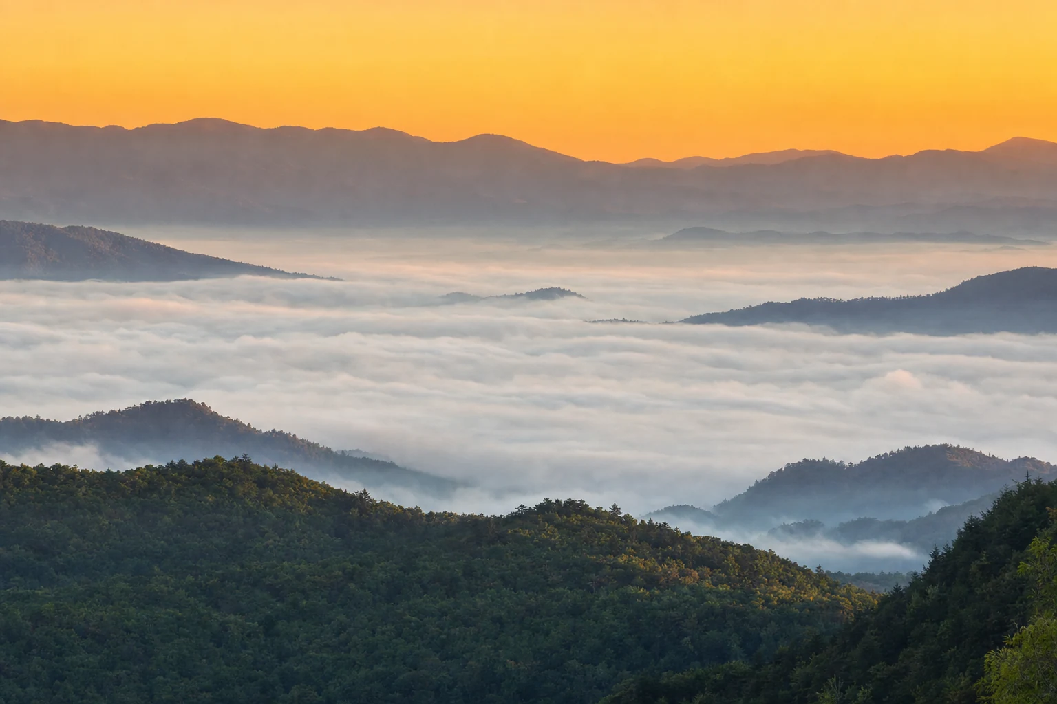
Cloud inversions
A cloud inversion (valley fog below clear ridges) forms on cold clear mornings after a warm rainy day. Conditions:
- Cold air settles into valleys overnight
- Clear sky lets the ground radiate heat
- Air moisture condenses as valley-fill fog
- Ridges remain above the fog, often at 4,000 ft
Best viewing spots: Newfound Gap, Kuwohi observation tower, Morton Overlook, Foothills Parkway high points (Look Rock in particular), Balsam Mountain.
Best time: October-January, about 30 minutes before to 60 minutes after sunrise. Drive up in the dark; shoot at first light.
The "smoke"
The Smokies' namesake haze is real. It's volatile organic compounds (terpenes) released by the forest, combined with water vapor. Conditions:
- Warm humid days produce the most visible smoke
- Morning smoke often fills valleys, clearing by midday
- August is the smokiest month
- The smoke is a natural phenomenon; it predates any industrial emissions
The modern haze, unfortunately, is partly anthropogenic — regional air pollution is a real issue. Park views can be obscured on high-pollution days. The EPA and the park publish visibility forecasts.
What to pack
- Rain jacket, every trip, every season. Don't treat this as optional
- Warm layer, every trip, every season. Mountain cold surprises people
- Good boots with traction. Wet rocks are more dangerous than the temperature
- Windbreaker. Ridgetop wind cuts through summer layers
- Water. Altitude and exertion dehydrate you faster than you think
- Sunscreen. UV at 5,000 ft is stronger than at sea level, even through haze