

Location Hub
Great Smoky Mountains National Park
The most-visited national park in the U.S. — 522,000 acres of Appalachian wilderness, 800+ miles of trails, 1,500 bears, the reintroduced Cataloochee elk herd, and cabins, churches, and mills older than the park itself.
356 curated entries across 7 categories.
Great Smoky Mountains National Park is the most-visited national park in the United States — 12+ million annual visitors, three times Yellowstone and Yosemite combined — and a UNESCO World Heritage Site protecting 522,000 acres of old-growth forest, 800+ miles of trails, 2,900 miles of streams, 1,500 black bears, and 200+ elk. The park straddles the Tennessee–North Carolina line along the spine of the southern Appalachians, with 16 peaks above 6,000 feet.
The park has no entrance fee and is open 24 hours a day, 365 days a year. A Park It Forward parking tag ($5 daily / $15 weekly / $40 annual) is required for any vehicle parked more than 15 minutes inside park boundaries, available online at recreation.gov or at visitor centers and automated kiosks. Roads: Newfound Gap Road (US-441) crosses the park in 33 miles; Little River Road, Cades Cove Loop, Roaring Fork Motor Nature Trail, Foothills Parkway, and the Heintooga Ridge Road add corridors on the TN side, with the Blue Ridge Parkway terminus at Cherokee anchoring the NC side.
Two notes for 2025–2026: Clingmans Dome was officially renamed Kuwohi in 2024, reflecting its ancestral Cherokee name. Chimney Tops Trail remains closed at the summit following the 2016 wildfires but reopened to a lower overlook at 1.75 miles. Check nps.gov/grsm current conditions before any hike — weather, ice, and maintenance routinely close roads and trails, especially at higher elevations in winter and during bear-activity seasons.
Established
1934
Acres
522,427
Annual visits
12M+
Highest peak
Kuwohi 6,643 ft
Insider logistics
Get the parking tag first
Every park vehicle parked more than 15 minutes needs a Park It Forward tag. Buy online ahead or at a kiosk at any trailhead. A single $40 annual tag covers a whole year of visits for the same vehicle.
Mountain weather
Temperatures at 6,000 feet run 15–20°F cooler than the valleys. Sudden storms year-round. Pack a rain layer and warm layer even in July, and check the summit forecast not just the valley one.
Dogs, bicycles, drones
Dogs are prohibited on all park trails except the paved Gatlinburg Trail and Oconaluftee River Trail. Bicycles are limited to roads and the Cades Cove Loop. Drones are prohibited parkwide.
Hiking trails
Gatlinburg, TN
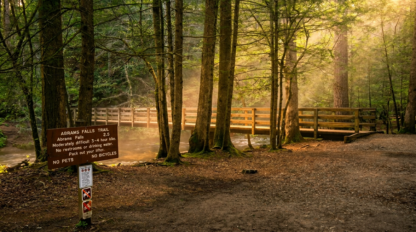
Abrams Falls Trail
5-mile out-and-back, moderate, 675 ft gain hiking trail in Great Smoky Mountains National Park.
Gatlinburg, TN
Ace Gap Trail:
hiking trail in Great Smoky Mountains National Park.
Gatlinburg, TN
Alum Cave Trail to Mount LeConte
Alum Cave Trail to Mount LeConte — 5 miles to Alum Cave Bluffs (out-and-back), 10 miles to Mount LeConte (out-and-back) trail, Moderate to Alum Cave Bluffs, Strenuous to Mount LeConte.
Gatlinburg, TN
Andrews Bald Trail (via Forney Ridge Trail)
1.8-mile out-and-back, moderate, 300 ft gain hiking trail in Great Smoky Mountains National Park.
Bryson City, TN
Appalachian Trail (AT) - Fontana Dam to Cheoah Bald
30-mile point-to-point, strenuous hiking trail in Great Smoky Mountains National Park.
Gatlinburg, TN
Appalachian Trail (AT) - Various Sections
Appalachian Trail (AT) - Various Sections — 71 miles within GSMNP (point-to-point) trail, Strenuous (overall), sections vary..
Gatlinburg, TN
Backcountry Horse Camp Trails (various):
hiking trail in Great Smoky Mountains National Park.
Gatlinburg, TN
Bald River Falls Trail
5.6-mile out-and-back, moderate, 800 ft gain hiking trail in Great Smoky Mountains National Park.
Gatlinburg, TN
Balsam Corner Trail:
hiking trail in Great Smoky Mountains National Park.
Gatlinburg, TN
Balsam Mountain Trail
5.8-mile loop, strenuous, 1,300 ft gain hiking trail in Great Smoky Mountains National Park.
Gatlinburg, TN
Bartram Trail - Various Sections
100-mile point-to-point, moderate hiking trail in Great Smoky Mountains National Park.
Gatlinburg, TN
Bearpen Hollow Trail:
hiking trail in Great Smoky Mountains National Park.
Waterfalls
Gatlinburg, TN
Abrams Falls
20-foot waterfall in Great Smoky Mountains National Park. Reached via a 2.5-mile moderate hike.
Gatlinburg, TN
Baby Falls
10-foot waterfall in Great Smoky Mountains National Park.
Gatlinburg, TN
Bald River Falls
90-foot waterfall in Great Smoky Mountains National Park.
Gatlinburg, TN
Benton Falls
65-foot waterfall in Great Smoky Mountains National Park. Reached via a 1.5-mile moderate hike.
Gatlinburg, TN
Big Creek Cascades (various)
5-foot waterfall in Great Smoky Mountains National Park.
Highlands, NC
Bridal Veil Falls (Highlands, NC)
Bridal Veil Falls (Highlands, NC) — on Cullasaja River, Roadside view (can drive behind falls, but road often closed due to rockfall) trail, Very Easy (roadside view), about 45 feet.
Gatlinburg, TN
Cataract Falls
Located near the Sugarlands Visitor Center (Gatlinburg, TN), this is an extremely easy 0.6-mile roundtrip walk.
Gatlinburg, NC
Cullasaja Falls
Cullasaja Falls — on Cullasaja River, Roadside view (no safe trail to base) trail, Easy (roadside view, but hazardous parking), about 200 feet (long, powerful cascade).
Gatlinburg, TN
Deep Creek Cascades (various)
5-foot waterfall in Great Smoky Mountains National Park.
Attractions
Sevierville, TN
Adventure Park at Five Oaks
Located at 1628 Parkway, Sevierville, TN 37876, this park offers a variety of zipline courses with varying lengths and heights, including some of the longest and highest in the Smokies.
Sevierville, TN
Floyd Garrett's Muscle Car Museum
: Type: Museum.
Sevierville, TN
Foxfire Mountain Adventure Park
: Type: Adventure Park.
Sevierville, TN
Sevier Air Trampoline & Ninja Warrior Park
: Type: Adventure Park.
Sevierville, TN
Smoky Mountain Knife Works
: Type: Retail/Museum.
Sevierville, TN
Smoky Mountain Outdoor Center (SMOC)
: Type: Outdoor Adventure.
Sevierville, TN
Tennessee Museum of Aviation
: Type: Museum.
Sevierville, TN
The Apple Barn Village
: Type: Shopping/Dining.
Sevierville, TN
The Coaster at Goats on the Roof
: Type: Alpine Coaster.
Sevierville, TN
Wilderness at the Smokies
: Type: Water Park Resort.
Scenic overlooks
Gatlinburg, TN
Balsam Mountain Overlook
: The terminus of the one-way section, offering expansive views.
Gatlinburg, TN
Bunches Bald Overlook (MP 440.9)
: Offers views towards Bunches Bald, often with long-range visibility.
Townsend, TN
Cable Mill Historic Area (MP 5.5)
: A cluster of historic buildings, including a working grist mill, offering views of the creek and surrounding fields.
Townsend, TN
Cades Cove Overlook (Before Loop Entrance)
: Offers a distant perspective of the Cades Cove area and its surrounding peaks.
Townsend, TN
Cades Cove Overlook (MP 22)
: Offers a distant perspective of the Cades Cove area and its surrounding peaks.
Gatlinburg, NC
Campbell Overlook (TN Side)
: Approximately MP 5.5, this overlook provides a framed view of the mountains.
Townsend, TN
Carter Shields Cabin Pullout (MP 9.5)
Scenic overlook in GSMNP. Big mountain views.
Cherokee, TN
Cherokee National Forest Overlook (TN Side)
Scenic overlook in GSMNP. Big mountain views.
Gatlinburg, TN
Chilhowee Lake Overlook
Scenic overlook in GSMNP. Big mountain views.
Campgrounds
Gatlinburg, TN
Abrams Creek Campground
frontcountry campground near Gatlinburg with 16 sites.
Gatlinburg, TN
Big Creek Campground
A small, primitive campground on the North Carolina side, offering a very rustic experience.
Townsend, TN
Cades Cove Campground
Located within the iconic Cades Cove loop, this campground offers easy access to the valley's historic sites, wildlife viewing, and hiking/biking opportunities.
Maggie Valley, TN
Cataloochee Campground
frontcountry campground near Maggie Valley with 27 sites.
Cherokee, TN
Cherokee / Great Smokies KOA Holiday
private campground near Cherokee with 150 sites.
Cosby, TN
Cosby Campground
A more rustic and quieter option on the Tennessee side, Cosby is known for its peaceful atmosphere and access to challenging hiking trails.
Gatlinburg, TN
Deep Creek Campground
Near Bryson City, NC, Deep Creek is popular for its tubing opportunities on Deep Creek and access to waterfalls.
Gatlinburg, TN
Elkmont Campground
Located along the Little River, Elkmont is one of the most popular campgrounds, known for its scenic beauty, proximity to hiking trails (e.g., Laurel Falls, Gatlinburg Trail), and the historic Elkmont Ghost Town.
Gatlinburg, TN
Gatlinburg KOA Holiday
private campground near Gatlinburg with 100 sites.
Cabin rentals
Gatlinburg, TN
American Patriot Getaways
cabin rental company in Gatlinburg.
Gatlinburg, TN
Aunt Bug's Cabin Rentals
cabin rental company in Gatlinburg.
Gatlinburg, TN
Auntie Belham's Cabin Rentals
cabin rental company in Gatlinburg.
Gatlinburg, TN
Bear Camp Cabin Rentals
cabin rental company in Gatlinburg.
Gatlinburg, TN
Blackberry Mountain
cabin rental company in Gatlinburg.
Gatlinburg, TN
Bluff Mountain Rentals
cabin rental company in Gatlinburg.
Gatlinburg, TN
Cabins at the Crossing
cabin rental company in Gatlinburg.
Gatlinburg, TN
Cabins for YOU
Provides a comprehensive selection of cabins in Gatlinburg and Pigeon Forge, focusing on matching guests with the perfect property based on their needs, whether it's a romantic getaway or a large family gathering.
Pigeon Forge, TN
Cabins of Pigeon Forge
cabin rental company in Pigeon Forge.
Historic buildings
Gatlinburg, TN
Alfred Reagan Place:
The distinctive pink house and its tub mill provide a unique cultural subject.
Gatlinburg, TN
Appalachian Club:
Preserved club building in the Elkmont: A Resort Community's Echoes area (built 1910).
Gatlinburg, TN
Apple House:
Preserved storage building in the Oconaluftee / Mountain Farm Museum: A Living History Exhibit area (built 19).
Townsend, TN
Becky Cable House:
Preserved cabin in the Cades Cove: A Window to Pioneer Life area (built 1879).
Maggie Valley, TN
Beech Grove School:
A one-room schoolhouse dating to 1901, providing insight into early rural education.
Gatlinburg, TN
Blacksmith Shop:
Preserved workshop in the Oconaluftee / Mountain Farm Museum: A Living History Exhibit area (built 19).
Gatlinburg, TN
Bote Mountain Road Shelter:
Preserved shelter (historic) in the Elsewhere in the Park area (built 1930).
Gatlinburg, TN
Bunkhouse (Porters Creek Trail):
Preserved bunkhouse in the Elsewhere in the Park area (built 1920).
Gatlinburg, TN
Burchfiel Cabin:
Preserved cabin in the Elsewhere in the Park area (built 1890).
Where to stay
Near the Great Smoky Mountains National Park area
Lodging in and around Great Smoky Mountains National Park — cabins, hotels, campgrounds. Prices shown live.
Map powered by Stay22. Prices and availability update live.