
The two-day Smokies weekend has a natural logic to it: the western coves on the first day, the high ridge on the second. Both reward early starts above almost everything else, and both turn into a very different experience if you show up after 10am in summer or fall.
Day 1: Cades Cove and Abrams Falls
Plan to be at the Cades Cove loop entrance by 7am, which means leaving Gatlinburg no later than 6:15. The drive runs west on US-321 to Townsend, then south on Laurel Creek Road to the loop entrance, a drive of roughly 45 minutes in light traffic.
The 11-mile one-way loop is the kind of road where 5 mph feels fast once the wildlife shows up. White-tailed deer are almost guaranteed; black bear sightings happen regularly in the early morning hours, particularly in the open meadow sections near the Hyatt Lane and Sparks Lane junctions. Pull completely into designated pullouts when stopping: the road has no shoulder to speak of, and traffic backs up fast once a bear draws a crowd.
On Wednesday and Saturday mornings from late May through September, the loop closes to motor vehicles until 10am and opens only to cyclists and pedestrians. If you're visiting during those months and want to drive the loop, plan for any other morning of the week.
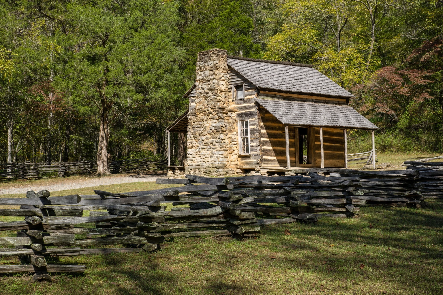
The historic structures along the loop are worth slowing for. The Cable Mill area, around mile marker 5.5, is the most concentrated cluster: an operational grist mill, the Becky Cable House, and outbuildings that the park maintains in working condition. The Carter Shields Cabin, near the end of the loop at mile 9.5, sits more quietly in the field and sees fewer visitors than the mill area. The Cades Cove Methodist Church, one of three preserved churches on the loop, is stark white against the tree line and dates to 1902.
After the loop, drive to the Abrams Falls trailhead, signposted along the loop road. The trail is five miles round-trip with moderate elevation change, ending at a 20-foot waterfall with a wide plunge pool. It crosses Abrams Creek; water levels vary significantly by season, so check current park conditions before assuming a straightforward crossing. Budget about two and a half hours.
Before your first in-park stop, make sure you have a Park-It-Forward tag: $5 per day, purchased online or at a self-service kiosk near the park entrance. It's required at trailheads and overlooks throughout the park.
There's no food service inside the cove, so pack lunch or plan to eat back in town. Finishing the loop and the hike typically gets you back to Gatlinburg by early to mid-afternoon. For dinner, Bennett's Pit Bar-B-Que is a reliable choice; if you want to keep it light after a long day on your feet, Crockett's Breakfast Camp serves its full menu through the afternoon.
Day 2: Newfound Gap Road, Kuwohi, and a Town Afternoon
Leave by 7:30am. Newfound Gap Road (US-441) is the only paved road crossing the ridge, running 33 miles from Gatlinburg south to Cherokee, NC, and taking about 45 minutes in clear conditions. Morning fog at the higher elevations is common in spring and fall; drive accordingly.
The Newfound Gap overlook sits at 5,046 feet on the Tennessee-North Carolina state line, with long views into both sides of the ridge. Worth a short stop, but the crowds build quickly: tour buses typically arrive by 9:30am.
From Newfound Gap, the Kuwohi spur road (formerly Clingmans Dome Road) runs seven miles to the parking area. Kuwohi sits at 6,643 feet, the highest point in the park and the highest summit in Tennessee. The parking area is at roughly 6,300 feet; the half-mile concrete ramp to the observation tower gains about 300 feet and is steep enough that many visitors underestimate it. The temperature at that elevation runs 10 to 15 degrees cooler than Gatlinburg even in summer. Bring a layer.
If the tower area feels congested, the Andrews Bald Trail is the better option. It leaves from the same parking lot via the Forney Ridge Trail, running 1.8 miles each way through spruce-fir forest before opening onto a grassy bald with long views south and west. Very few people make the full hike, and the bald is usually quiet even when the parking lot is packed. Round-trip takes about two hours.
Head back down Newfound Gap Road by early afternoon. The Chimney Tops Overlook on the Tennessee side frames the double-summit profile well and requires only a brief stop. Back in Gatlinburg, let the rest of the day move without a schedule. The Gatlinburg Arts & Crafts Community, along East Parkway, has working studios open to visitors and is one of the larger craft loops in the southern Appalachians; an hour there rarely feels like enough. Ober Mountain's aerial tramway departs from downtown and reaches the mountain summit in about eight minutes each way, with chair lifts, a mountain coaster, and other summer operations running through the warmer months.
For dinner on the second night, Chesapeake's Seafood and Raw Bar and Calhoun's Gatlinburg are both reliable without advance reservations, though lines form after 6pm during peak season.
Where to Base
Gatlinburg is the practical choice for this itinerary. The park entrance sits at the edge of town, lodging options are wide, and both days begin and end there without significant detour. Townsend is quieter and a shorter drive to Cades Cove, but restaurants and accommodations are limited; it works if Cades Cove is the sole priority and you're comfortable driving back through the park for dinner.
Skip the Pigeon Forge Parkway corridor for this itinerary. The traffic in and out adds real time to both mornings.