
Bowling Green sits about 265 miles from Gatlinburg, which puts it roughly 4 hours down the road on a clean run. The bulk of that drive is interstate, well-signed and familiar to anyone who has made the Nashville-to-Knoxville corridor before. Plan on at least a weekend; 265 miles each way makes a day trip more effort than it's worth.
The drive from Bowling Green
Take I-65 south toward Nashville, then pick up I-40 east on the far side of the city and follow it through Knoxville until the mountains come into view. Traffic through Nashville is the one reliable variable: weekday morning and evening rush hours can add 30 to 45 minutes, so departure time matters. Knoxville occasionally slows during University of Tennessee game weekends, though rarely by more than 20 minutes. From the Sevierville area, US-441 south carries you the final stretch into Gatlinburg; expect that last 30 minutes to stretch longer during summer weekends when Parkway traffic backs up.
If you're flying rather than driving, Nashville International (BNA) is the nearest major airport to Bowling Green, with rental cars close to the terminal and I-40 east accessible within minutes of leaving.
How long to plan for
A day trip from Bowling Green puts 8 hours of driving into the equation before you've made a single stop inside the park. Two nights gives you a genuine look: one full day in the national park, one afternoon in a gateway town without racing back to the car. Three nights is where the trip starts to feel complete, with time for a longer hike, a slow loop through Cades Cove, and an evening to walk Gatlinburg's Parkway without watching the clock. Four or five nights makes sense if you want both sides of the mountains and a detour through Cherokee or Bryson City.
What to do when you arrive
The national park charges no entrance fee, but any vehicle stopped for 15 minutes or more needs a Park-It-Forward parking tag: $5 for a day, $15 for a week, $40 for a year. Purchase one at kiosks near the park entrances or online before you leave home.
Gatlinburg is the main access point for trails on the Tennessee side. Laurel Falls is a paved 2.6-mile round trip to one of the park's most-visited waterfalls. Alum Cave Trail runs 4.4 miles round trip from a trailhead on Newfound Gap Road, climbing through interesting geology to the Alum Cave Bluffs; the terrain gets more dramatic the higher you go. Roaring Fork Motor Nature Trail loops through old-growth forest and gives access to Grotto Falls, where the trail passes directly behind the water.
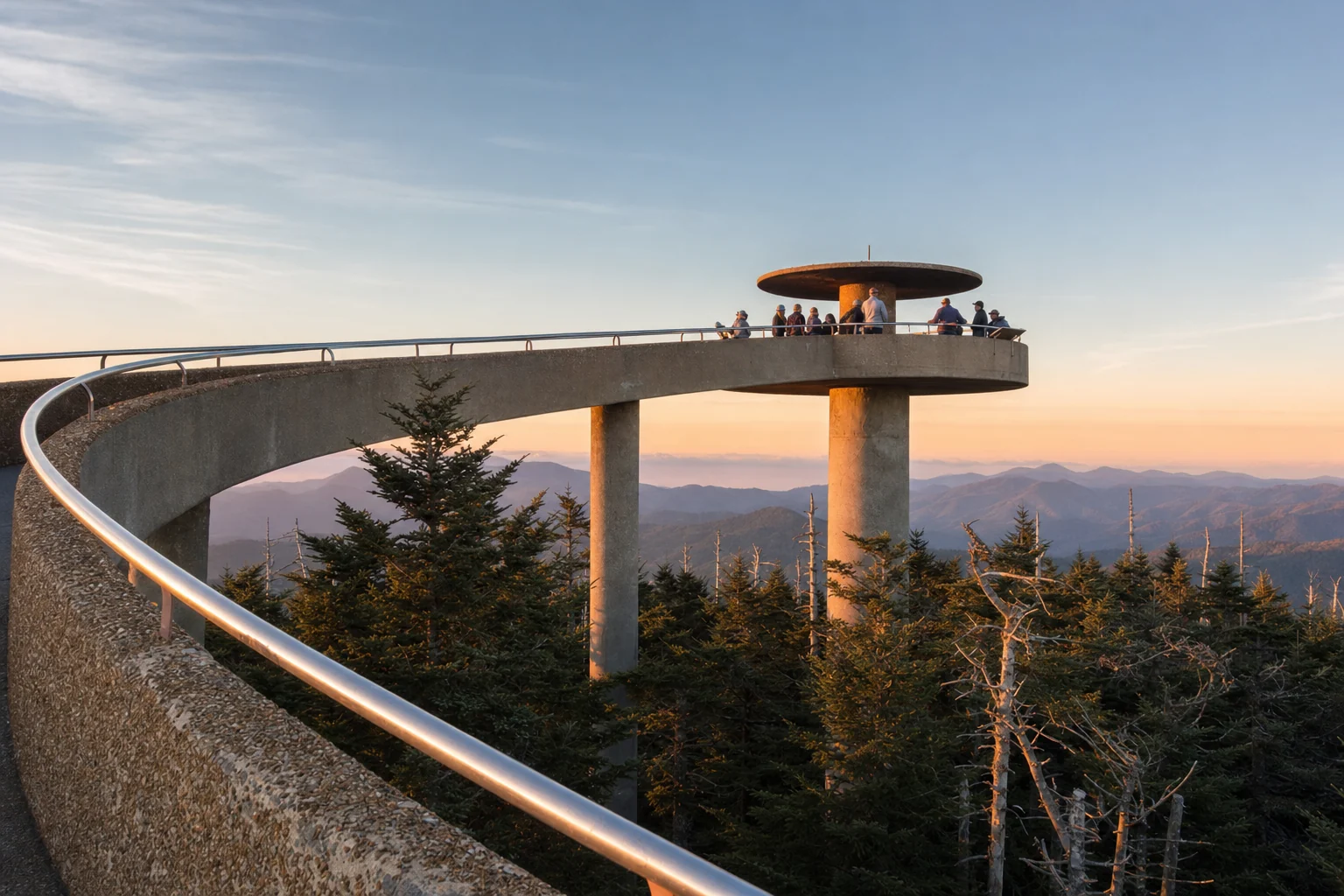
Newfound Gap Road (US-441) is the only paved crossing through the park. Kuwohi, historically known as Clingmans Dome, sits at 6,643 feet; a steep half-mile trail from the parking area reaches the observation tower at the summit. Cades Cove on the Tennessee side runs an 11-mile one-way loop past preserved 19th-century homesteads and open meadows where black bears and deer appear often. Cataloochee Valley on the North Carolina side is the better elk spot, with the animals most active at dawn and dusk.
Outside the park, Dollywood in Pigeon Forge is a full day on its own. The ride collection is serious, the seasonal festivals are well-run, and the setting against the mountains is genuinely good. Anakeesta has a gondola and a tree canopy walk above the Gatlinburg skyline. Ripley's Aquarium of the Smokies sits on the Parkway and runs 2 to 3 solid hours. The SkyLift Park connects two peaks via a pedestrian suspension bridge with real open-air exposure; it's not for anyone uncomfortable with heights.
Cherokee, NC, about 32 miles from Gatlinburg via US-441, sits within the Qualla Boundary. The Oconaluftee Visitor Center there is one of the park's better entry points, and elk graze the meadows near the village most evenings. Bryson City is worth the detour if the Great Smoky Mountains Railroad or tubing on Deep Creek interests you.
Where to stay
Cabin rentals dominate the market around Gatlinburg and Pigeon Forge, particularly along US-321 and Glades Road north of town. Sevierville, close to the I-40 interchange, has chain hotel options at generally lower prices than the Gatlinburg Parkway. Townsend sits at the park's quieter western entrance, giving you quick access to Cades Cove and the Abrams Falls trailhead without the Parkway congestion. Cherokee is a sensible base if you're splitting time between the Tennessee and North Carolina sides. You can compare live cabin and hotel availability on the map below.
Best time to make the trip
July is peak season, and US-441 through the park can slow to a crawl on weekends. Spring is a strong window: wildflowers along lower-elevation trails peak in April and early May, temperatures are comfortable, and the crowds are a fraction of summer. Fall foliage at the higher elevations starts late September and rolls downslope through October into early November; that window books fast, and accommodation prices reflect it. Winter is quiet throughout, with some road closures at elevation but far fewer people everywhere else.